Autonomous navigation depends on continuous estimates of position, velocity and orientation. However, the quality and availability of the information used to estimate that state can vary significantly with the operating environment.
GNSS signals may become degraded or unavailable, while vision- and LiDAR-based systems can be affected by environmental conditions or limited features. Inertial measurement provides continuous motion data that complements these external sources, helping navigation systems maintain a reliable state estimate as sensing conditions change.
Reliable navigation is not just about estimating position.
It is about maintaining confidence in the robot’s state as sensing conditions change.

GNSS is an important source of positioning information, but autonomous systems cannot always rely on continuous satellite availability.
Explore the principles behind inertial navigation, sensor fusion and GNSS/INS architectures, and learn how complementary sensing technologies can support navigation when satellite positioning becomes degraded or unavailable.
Engineering challenge | HBK contribution |
| GNSS becomes degraded or unavailable in urban environments, under vegetation, around infrastructure or indoors. | GNSS/INS solutions combine satellite positioning with inertial measurements, helping maintain state information during temporary degradation or loss of GNSS. |
| Vision or LiDAR localisation can lose confidence when lighting, visibility, environmental conditions or available features change. | Continuous inertial measurement complements external localisation sources, providing acceleration and angular-rate information independently of visual features. |
| Rapid motion, vibration and changing platform dynamics can challenge measurement quality and state-estimation performance. | High-performance inertial sensors provide low-noise acceleration and angular-rate measurements for demanding dynamic environments. |
| Different operating environments provide different navigation references. | Inertial data can be combined with GNSS and other aiding sources within the robot’s sensor-fusion architecture to support more robust state estimation |
Reliable robot navigation depends on more than knowing where a robot is. It requires continuous motion measurements, complementary sensing and consistent state estimation to support navigation and control as operating conditions change.
Identify the dynamics that challenge navigation accuracy
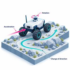
As a robot accelerates, rotates, changes direction or travels across uneven terrain, its motion is affected by changing dynamics and external disturbances. These conditions place demands on navigation accuracy and control responsiveness.
Understanding the robot’s physical behaviour helps engineers identify the motion parameters, measurement ranges and update rates required to support reliable state estimation.
Maintain motion measurements when external references are unavailable
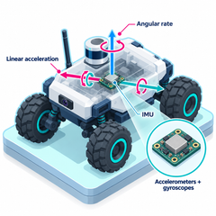
Inertial Measurement Units (IMUs) continuously measure linear acceleration and angular rate, providing high-frequency motion data independently of external positioning references. This is particularly valuable during rapid manoeuvres or when GNSS and other aiding sources become unavailable.
Sensor accuracy, noise, bias stability and update rates influence how effectively these measurements support orientation estimation and navigation.
Reduce drift and improve robustness through sensor fusion
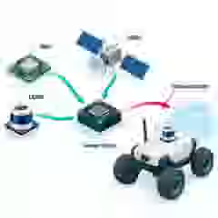
Inertial measurements provide continuous motion information, but errors accumulate when they are integrated over time. External aiding sources such as GNSS, LiDAR and vision can help constrain this drift, although their availability and accuracy vary with operating conditions.
Combining complementary measurements enables navigation architectures to compensate for individual sensor limitations and maintain more robust localisation when reliable aiding information is available.
Provide consistent state information for navigation decisions
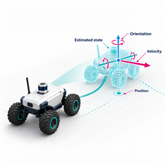
Navigation and control systems require a coherent estimate of the robot’s position, velocity and orientation rather than individual sensor readings. State-estimation algorithms use available measurements to update this information while accounting for sensor errors and uncertainty.
Estimation quality depends on sensor performance, system calibration, measurement timing and the availability of external aiding, directly influencing the information available for trajectory tracking and control.
Enable continuous feedback for accurate trajectory tracking
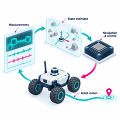
The estimated robot state provides essential feedback to the navigation and motion-control architecture. By comparing the robot’s current position, velocity and orientation with its intended trajectory, the control system can determine the adjustments needed to maintain the desired motion.
As the robot moves, new measurements continuously update the state estimate, closing the feedback loop between physical motion, measurement and control. This supports accurate trajectory tracking and enables the robot to respond to disturbances and changing operating conditions.
An IMU measures acceleration and angular rate. An AHRS processes inertial and other available measurements to provide attitude and heading, while a GNSS/INS combines inertial measurement with GNSS to estimate position, velocity and orientation.
Inertial sensing provides continuous information about how the robot is accelerating and rotating without relying on visual features or an external positioning signal. This information can complement GNSS, LiDAR, vision and other localisation sources within a sensor-fusion architecture.
Key considerations include required accuracy, bias stability, noise, dynamic range, vibration and shock environment, update rate, interfaces, size, weight and integration requirements. The appropriate performance level depends on the robot’s dynamics, navigation architecture and available aiding sources.

This will bring together HBM, Brüel & Kjær, nCode, ReliaSoft, MicroStrain and Discom brands, helping you innovate faster for a cleaner, healthier, and more productive world.