


战术级嵌入式GNSS辅助惯性导航系统

3DM-CV7-GNSS/INS
3DM-CV7-GNSS/INS 是惯性导航技术的最新创新成果,它在极其紧凑轻巧的 OEM 外形尺寸内,提供了战术级的性能。
这款传感器专为导航和定位应用而设计,在这些应用中,尺寸、重量和成本是主要考虑因素。
每个单元都在整个工业温度范围内进行了全面的多点校准,并采用我们久经验证的自适应扩展 Kalman 滤波,确保在各种运行环境下都能达到极佳精度和稳定性。
除了核心的惯性导航功能外,3DM-CV7-GNSS/INS 还内置了用于 GNSS 辅助导航的机载 GNSS 接收器,以及先进的定向算法、精确的内部时间管理和高度灵活的事件触发系统,从而能够轻松应对复杂的导航应用。
0.05° 横滚和俯仰
重量仅15.6克
| Document | Type | Language |
|---|---|---|
| 3DM-CV7-GNSS/INS Data Sheet | 數據表 | English |
| Micro D-to-USB Communication and Power Cable | Accessory Guide | English |
| Craft Cable with Micro DB9 and Flying Leads | Accessory Guide | English |
| Micro-D to RS232 Communication and Power Cable | Accessory Guide | English |
| 3DM-CV7-GNSS/INS User Manual (Online) | 操作說明 | English |
| C-Series Connectivity Board Interface Control Document | 安裝說明 | English |
| GV7-CV7 Firmware Change Log | Release Note | English |
Sales documents
| Document | Type | Language |
|---|---|---|
| 3DM-CV7-GNSS/INS Outage Test Report | Whitepaper | English |
| Document | Type |
|---|---|
| 3DM-CV7-GNSS/INS CAD Model | CAD Step Files |
| MicroStrain 7-Series Inertial Sensor Firmware | Firmware |
| Property | Value |
|---|---|
| Type | Inertial Navigation (INS) |
| Performance Grade | Tactical Grade |
| Features | Accelerometer, Gyroscope, Magnetometer, Barometer |
| Random Walk | Accel: 29.5 µg/√/Hz, Gyro: 0.14 °/√hr |
| Bias Instability (Gyroscope) | 1.5 °/hr |
| Bias Instability (Accelerometer) | 18 μg |
| Hysteresis | Accel bias: 0.75 mg, Accel gain: 600 PPM, Gyro bias: 0.03 °/s, Gyro gain: 1000 PPM |
| Communication Port Type | Samtec FTS-105 (2x5) |
| Communication Interface | TTL serial, USB |
| Update Rate | IMU: 1000 Hz, EKF: 1000 Hz |
| Inputs/Outputs | 4xGPIO |
| Weight | 15.6 g |
| Weight | 0.55 oz |
| Size | 38 mm x 30 mm x 10.2 mm |
| Size | 1.49 in x 1.18 in x 0.40 in |
| Power Consumption | 0.896 W |
| Input Voltage | 3.2 V to 5.2 V |
| Minimum Operating Temperature | -40 °C |
| Maximum Operating Temperature | 85 °C |
| Minimum Operating Temperature | -40 °F |
| Maximum Operating Temperature | 185 °F |
| MTBF | 1327311 h |
| GNSS Constellations | GPS, GPS/QZSS, GLONASS, Galileo, BeiDou |
| GNSS Frequency Bands | L1C/A, L5, L10F, E1B/C, B1, B2 |
| GNSS Input(s) | Onboard Receiver(s) |
| Sensing Range (Accelerometer) | 4 g, 8 g, 16 g |
| Sensing Range (Gyroscope) | 250 °/s, 500 °/s, 1000 °/s |
| Sensing Range (Magnetometer) | 8 Gauss |
| Sensing Range (Pressure) | 1260 mbar |
| Accuracy | Roll/Pitch (dynamic): 0.05 °, Roll/Pitch (static): 0.05 °, Heading (dynamic): 0.25 ° |
| Ingress Protection Rating | Not Rated |
| Housing Material | Aluminum |
| Software | MSCL, ROS, SensorConnect, InertialConnect |
| Mounting Style | Embeddable, Screw Down, Precision Alignment |

NDAA Compliant
Deploy with confidence in government applications.

ITAR-Free
Simplify your global operations with reduced export restrictions. ITAR-free classification streamlines international deployment and reduces regulatory complexity.

L1/L5 Support
Achieve superior positioning accuracy with dual-frequency GNSS reception. L1/L5 support provides enhanced performance in challenging environments and faster convergence times.

Dual Antenna Heading
Maintain precise heading determination even when stationary. Dual antenna configuration delivers reliable azimuth accuracy independent of vehicle movement or GPS velocity.

RTK/PPP/SBAS
Adapt to any precision requirement with comprehensive correction support. RTK, PPP, and SBAS compatibility ensures centimeter-level accuracy across diverse operational scenarios.

Access your sensor's comprehensive online user manual. Find detailed setup instructions, calibration procedures, troubleshooting guides, and technical specifications all in one convenient location.
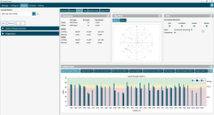
InertialConnect is the latest software solution for MicroStrain inertial sensors. With InertialConnect, you can easily configure your sensors, adjust parameters, upgrade firmware, and deploy preconfigured parameter files. You can also verify sensor outputs with intuitive visualizations, including times eries data, position data, and statuses.
InertialConnect is compatible with both PC desktop and Linux operating systems, making it your go-to solution for precision and efficiency in inertial sensor management.

SensorConnect is the next generation in desktop sensing software.
From configuration of nodes and starting networks, to collecting and analyzing data in real-time, SensorConnect provides a modern, powerful experience with our Wireless, Inertial, and Displacement products.
Using our intelligent data collection and graphing algorithms, you are able to visualize massive amounts of data instantly, and then zoom in on points of interest just as fast.
Built in MathEngine functionality allows for both real-time and post-processed math, such as generating FFTs, averages, RMS, etc.

SensorCloud is a unique sensor data storage, visualization, and remote management platform that leverages powerful Cloud computing technologies to provide excellent data scalability, rapid visualization, and user programmable analysis.
MicroStrain sensors can instantly upload their data to SensorCloud via an ethernet-connected WSDA-2000. Once uploaded, your data is securely stored in the Cloud and can be accessed from anywhere, or downloaded for offline use.
Configurable alerts can be set to help notify you of real-time event in your data.
MathEngine allows you to perform analytics on your data, all in the Cloud. Pre-built functions are available for ease of use, while IPython Notebooks allow advanced users to write custom scripts to be run on their data once, or on a schedule.

SensorCloud RTK is a multi-continent, IP-based RTK cloud network that delivers centimeter-level position accuracy from day one without complex setup, featuring network coverage across the U.S., Europe and beyond.
When paired with compatible MicroStrain navigation systems, it offers seamless scalability from development to production with professional technical support throughout.
The MicroStrain Communication Library (MSCL) is our open-sourced API that simplifies writing code to interact with our sensors. MIP SDK is a lightweight C/C++ library for interacting with MicroStrain G and C-series products via baremetal and resource constrained microcontrollers.
Both APIs are readily available and fully-documented on GitHub, featuring valuable tools such as full documentation, example code, and a quick start guide.
Robot Operating System (ROS) is an open-source, meta-operating system for your robot. It provides the services you would expect from an operating system, including hardware abstraction, low-level device control, implementation of commonly-used functionality, message-passing between processes, and package management. ROS can be used in building and simulating robotics applications, as well as unmanned ground vehicles and simultaneous localization and mapping (SLAM). MicroStrain has an open source License free (MIT License) series of drivers specifically designed and tested for ROS.

PX4 is an open source flight control software for drones and other unmanned vehicles. The project provides a flexible set of tools for drone developers to share technologies to create tailored solutions for drone applications. PX4 provides a standard to deliver drone hardware support and software stack, allowing an ecosystem to build and maintain hardware and software in a scalable way. PX4 is fully supported on MicroStrain’s 3DM-CV7 family of inertial sensors.
The 3DM-CV7-GNSS/INS is an ultra-compact, tactical-grade GNSS-aided Inertial Navigation System that packs advanced navigation capabilities into just 15.6 grams and 38x30x10mm. It features onboard dual-frequency GNSS receivers with tightly coupled integration, making it the next evolution in inertial navigation technology for space-constrained platforms.
Tightly coupled integration means the GNSS and inertial sensors work together at the raw measurement level, providing superior performance compared to loosely coupled systems. This approach delivers more accurate navigation, better GNSS outage bridging, and robust performance in challenging environments where GNSS signals may be weak or intermittent.
The 3DM-CV7-GNSS/INS includes onboard dual-frequency GNSS receivers for complete autonomous navigation, while the 3DM-CV7-INS requires external GNSS input. The GNSS/INS version provides an all-in-one solution with tightly coupled integration, eliminating the need for separate GNSS receivers and simplifying system integration.
The system includes onboard dual-frequency GNSS receivers supporting L1/L5 frequencies for enhanced accuracy and robust signal tracking. The integrated GNSS provides autonomous positioning without requiring external receivers, while the tightly coupled architecture ensures optimal sensor fusion performance.
Onboard GNSS receivers provide:
Yes, the tactical-grade IMU with advanced Extended Kalman Filter maintains accurate navigation during GNSS outages. The tightly coupled architecture provides superior GNSS outage bridging compared to loosely coupled systems, ensuring continuous navigation in challenging conditions.
The 3DM-CV7-GNSS/INS is ideal for:
Absolutely. The system features sophisticated orientation algorithms, precise internal time management, and highly adaptable event triggering systems designed for complex navigation applications. Its compact size and tactical-grade performance make it perfect for autonomous robotics requiring reliable navigation.
The tried-and-tested Adaptive Extended Kalman Filter provides sophisticated sensor fusion between the onboard GNSS receivers and tactical-grade IMU. It automatically adapts to changing dynamics, ensures optimal accuracy and stability across diverse operational environments, and provides superior navigation performance.
The system combines tactical-grade inertial sensors, dual-frequency GNSS receivers, tightly coupled integration, and adaptive filtering to maintain accuracy in challenging environments. The comprehensive multi-point calibration over full industrial temperature range ensures consistent performance across operational conditions.
Yes, as part of the MicroStrain by HBK product line, the 3DM-CV7-GNSS/INS is NDAA compliant, making it suitable for U.S. government and critical infrastructure applications requiring secure navigation solutions.
The 3DM-CV7-GNSS/INS sets new benchmarks with its 15.6-gram weight, 38x30x10mm size, tactical-grade performance, onboard dual-frequency GNSS, tightly coupled integration, and ITAR-free classification - delivering capabilities unmatched in such a compact package.

This will bring together HBM, Brüel & Kjær, nCode, ReliaSoft, MicroStrain and Discom brands, helping you innovate faster for a cleaner, healthier, and more productive world.
 6212-3006
 6212-3024
